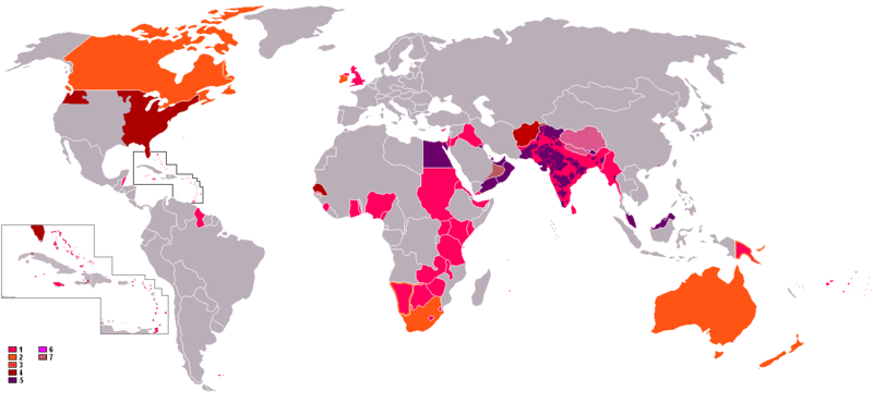
ไฟล์:British Empire Anachronous 7.png

ขนาดของตัวอย่างนี้: 800 × 370 พิกเซล ความละเอียดอื่น: 320 × 148 พิกเซล | 640 × 296 พิกเซล | 1,357 × 628 พิกเซล
ดูภาพที่มีความละเอียดสูงกว่า (1,357 × 628 พิกเซล, ขนาดไฟล์: 48 กิโลไบต์, ชนิดไมม์: image/png)
ประวัติไฟล์
คลิกวันที่/เวลาเพื่อดูไฟล์ที่ปรากฏในขณะนั้น
| วันที่/เวลา | รูปย่อ | ขนาด | ผู้ใช้ | ความเห็น | |
|---|---|---|---|---|---|
| ปัจจุบัน | 06:41, 8 พฤศจิกายน 2564 |  | 1,357 × 628 (48 กิโลไบต์) | Randomastwritter | jubaland |
| 15:04, 31 ตุลาคม 2564 |  | 1,357 × 628 (48 กิโลไบต์) | Randomastwritter | . | |
| 02:47, 14 มิถุนายน 2552 |  | 1,357 × 628 (41 กิโลไบต์) | Mnmazur | Reverted to version as of 20:37, 20 September 2007 - Spheres of influnce extended beyond Tibet but did not cover the entire country. Firthermore, even if they had, that map uses current Chinese borders and therefore filling in the country just doesn't wo | |
| 20:01, 18 เมษายน 2551 |  | 1,357 × 628 (55 กิโลไบต์) | LaGrandefr~commonswiki | {{Information |Description= {{en}}: An anachronous map of the British Empire (showing its many forms of control). The colours in the map key are explained according to their related numbers as follows: *1.Pink: colonies held by 1945 *2.Orange:Dominions | |
| 03:37, 21 กันยายน 2550 |  | 1,357 × 628 (41 กิโลไบต์) | Tarret | {{Information |Description=An anachronous map of the British Empire (showing its many forms of control). The colours in the map key are explained according to their related numbers as follows: *1.Pink: colonies held by 1945 *2.Orange:Dominions *3.Pink in |
หน้าที่มีภาพนี้
หน้าต่อไปนี้ โยงมาที่ภาพนี้:
การใช้ไฟล์ข้ามโครงการ
วิกิอื่นต่อไปนี้ใช้ไฟล์นี้:
- การใช้บน cs.wiki.x.io
- การใช้บน ro.wiki.x.io


